


Saint-Marc

josy31
User
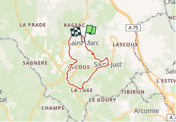

Length
11.1 km

Max alt
1060 m

Uphill gradient
259 m
Km-Effort
14.6 km

Min alt
913 m

Downhill gradient
258 m
Boucle
Yes
Creation date :
2018-04-17 15:52:54.979
Updated on :
2018-04-17 15:52:54.979
3h15
Difficulty : Easy

FREE GPS app for hiking
 SityTrail
IGN / Geographical institutes
SityTrail Plus
The world is yours!
About
Trail Walking of 11.1 km to be discovered at Auvergne-Rhône-Alpes, Cantal, Val d'Arcomie. This trail is proposed by josy31.
Positioning
Country:
France
Region :
Auvergne-Rhône-Alpes
Department/Province :
Cantal
Municipality :
Val d'Arcomie
Location:
Saint-Marc
Start:(Dec)
Start:(UTM)
515165 ; 4972107 (31T) N.
Comments